Wednesday 4 September 2019

Final flights 😕

After a pleasant two nights at Arkaroola it was time to embark on the last flights of this trip.

We left Arkaroola early for the short flight to Broken Hill so we could spend the afternoon looking around there.

On the leg to Broken Hill we crossed the beautiful Lake Frome but, unfortunately, it had no water in it so we missed out on seeing the lovely pinks and blues exhibited when water is present.  However, we did cross the dog fence which stretches for miles along the South Australia / New South Wales border.  It’s always fun to drop down (to 500ft of course) to fly along the few miles of this iconic fence that stops feral animals from getting into the farmland of New South Wales,

My son Andrew had arranged for us to meet Neil Taylor who is a Flying Doctor Pilot at the Broken Hill base and we enjoyed a tour of the base with Neil.  It was Neil’s day off and, he was prepared to show us over an aircraft but they were all out on jobs - bugger.  The RFDS does a fantastic job in the outback and are a vital service that is well regarded by all Australians.

We hired a rental car and went out to Silverton where Mad Max, Razorback and A Town Like Alice was filmed and also visited the Pro Hart gallery and the Miners Memorial at the top of the now decommissioned Broken Hill lead and zinc mine.

Andrew is a First Officer with Rex Airlines and months ago had asked to operate the evening flight into Broken Hill so he could meet up and spend the evening with us.  That wasn’t to be which was disappointing.  One of Rex’s Saab 340 aircraft had broken down earlier in the day and disrupted the schedules.  Andrew did get to Broken Hill as planned but then had to promptly crew the aircraft back to Adelaide again.  Bugger - so close but so far.

The following morning Simon and I said goodbye to Shelley and Pete who have accompanied us in their Cessna 182 for much of our trip.  Their last flight was to Camden (south of Sydney) and we had to return to Bathurst.  We’ve had so much fun with Shelley and Pete on this trip.  They’re great company and easy to get on with.  I’ve done several trips with them in Australia and South Africa and hope to do many more.

On our flight back to Bathurst we had a stonking tailwind and our little Cessna 172 was blown along at a paint-blistering 150kts at times.  On our track was a little town called Condobolin that we called in to stretch our legs, empty the bladder and swap pilots.

It was my duty to fly the last leg into Bathurst to return VH-BAC.  During the last 30mins we encountered some decent turbulence and VH-BAC bucked and kicked.  I'm sure she was resisting going home.

During our travels we must have flown through most of the bugs in Australia that had become baked onto the leading edges and VH-BAC’s fuselage was coated in the fine red dust that’s prevalent in the outback.  On a warm afternoon it was good to give her a well deserved wash before handing the keys back to the Bathurst Aero Club.


During the last 19 days we’ve enjoyed beautiful flying conditions in clear blue skies and lovely warm temperatures.  Most of the time we’ve enjoyed tailwinds or no wind and, although we’ve flown 4,571nm / 8,465km in a total of 50hrs none of the flights have seemed to drag.  Flying with Simon has been great, we’ve had many laughs and I’ve really enjoyed his company.  I’ve learned a lot from Simon and hope he also was able to take something away from this trip.

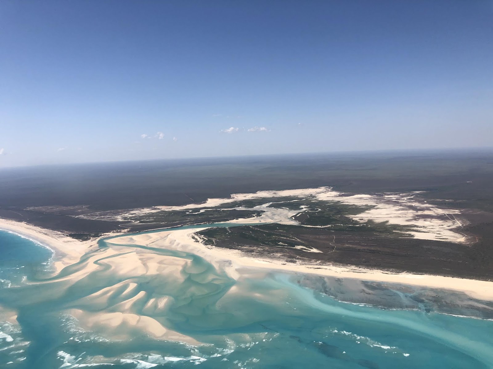
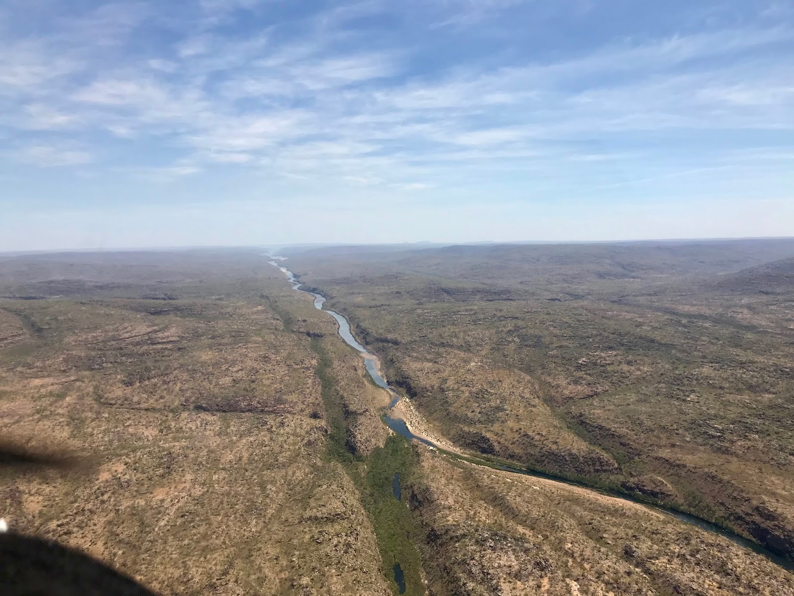
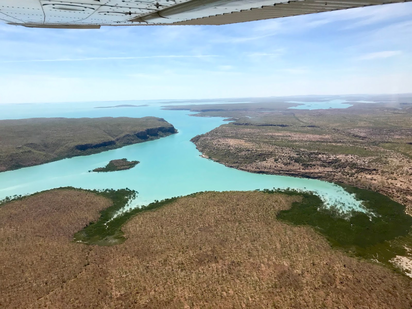
Flying in Australia is so different from flying in New Zealand.  Yes, the laws of aerodynamics are the same and the procedures we use are similar, but the country is vast, the distances are huge and the scenery (particularly in he Kimberley) is pure artwork.  We are blessed to be able to fly in New Zealand but I love the magnificent desolation here just as much.

Until next time ...


Final team photo before departing Broken Hill
(Simon, Shelley, Pete & me in front of C182 VH-BMJ)

Departing Broken Hill

Simon concentrating on the needles

The dusty land gives way to farms as we approach Bathurst

A wide approach into Bathurst to stretch our last flight just that wee bit longer

It’s a tradition of mine to say thank you to any aircraft that has transported me safely on a fantastic trip.  If you look after and appreciate an aircraft, it will look after you.

A day off in Arkaroola

Over the last couple of days we’ve done a lot of flying as we’ve crossed the middle of the Australian Continent so it was nice to have a day off in Arkaroola.

I like the Arkaroola Wilderness Sanctuary a lot.  This was my 3rd or 4th visit and I was looking forward to seeing Simon’s reaction to it.  Arkaroola is at the north end of the Flinders Ranges and is a dry and dusty place.  It boasts some of the oldest rocks in the world and you don’t have to look far to see evidence of massive geological lifting and tilting of the rock.

Arkaroola is owned by Doug Sprigg and we were honoured to be collected from the airstrip and driven the 10km or so to the village by Doug.  There was another pilot landing at the strip and so Simon and I really enjoyed a conversation with Doug about the assistance he provided to Jon Johansen while we waited.  Doug is a very clever guy and what he doesn’t know about aircraft engines doesn’t matter.  He helped Jon get the most power out of his Vans RV-4 engine for his two flights around the world and attempt to reach the South Pole.

Our full day at Arkaroola began with an 8km walk on one of the trails with Shelley and Pete and then I had a nice lazy afternoon reading my book while Simon went on the Ridgetop Tour.

I’d deliberately not told Simon much about the Ridgetop Tour but encouraged him to do it.  It’s a half day ride in a Landcruiser high up among the peaks of Arkaroola while learning about the geology, botany and wildlife of the place.  Arkaroola has a fascinating history which you learn about on the tour but the highlight is the Landcruiser ride up slopes that have to be seen to be believed.  As you climb these rough tracks you’d swear the vehicle will loose traction and/or the front wheels will lift and you’ll flip.  It’s a wild ride and you have to hold on tight.  Simon really enjoyed it - phew.

In the bar on the second night there was a big influx of people who’d arrived that day.  They were members of the Harry Ferguson Tractor Club who were touring the Flinders Ranges in their tractors!  19 tractors and associated support vehicles were on a 28 day trip and they were great people to talk to.  Most of the time they have been camping out at the Stations they were crossing so they were enjoying Arkaroola’s barb and restaurant when we met them.  It’s interesting to note they were just as passionate about their tractors and travels as we are about our aircraft.  Mind you I’d rather travel at 203km/hr at altitude and out of the dust rather than their sedentary 20km/hr.


Australian “bush” walk at Arkaroola
(Simon, Shelley, me & Pete)

Having a spell on a hot morning
(Me, Shelley & Pete)

Endangered Australian Yellow Footed Rock Wallaby which are well established at Arkaroola

Harry Ferguson Tractor Club lined up outside Arkaroola reception
(Photo shamelessly stolen from someone else's Facebook post as it was taken the day we left)


Monday 2 September 2019

Crossing the continent

Over the last few days we’ve completed the crossing of this big, dusty continent.  The route “through the middle” crosses some of the most remote areas of Australia and fuel and flight planning is important.

One of the longest legs on this trip is the 457nm flight SE from Halls Creek to Ayers Rock.  In zero-wind this requires a flight time of 4.2hrs with few options to land (at places where you could takeoff from).  A slight headwind was forecast for the day we completed this flight which, if you’re not careful, can quickly exhaust the fuel reserves.  Aviation law requires that flying of our type includes a planned fuel reserve of 30mins.  Australia has recently introduced a rule that requires you to declare an emergency if you begin to consume your fuel reserve.  Declaring a fuel emergency is the last thing we would want to need to do as there’s likely to be a mountain of paperwork and some hard questions asked.

Simon flew this leg and we departed early from Halls Creek to take advantage of the smooth flying conditions and as the forecast winds were more favourable at the lower altitudes earlier in the day.  After about 30 mins we passed Wolfe Creek crater which is impressive from the air and then set heading for Ayers Rock 400nm away.

During this leg we chatted away, had long periods of silence, consumed Minties and muesli bars.  For the first half of the leg the horizon is dead flat for 360 degrees. However, it’s far from boring and I never tire from watching the land slide by lost in my own thoughts.  “Magnificent desolation”.

During the second half of the leg rocky outcrops start to appear on land that is otherwise billiard-table flat.  Of course, as we’re tracking toward Ayers Rock, every bump on the horizon looks like The Rock!  About 70-80nm miles out the real Ayers Rock starts to come into view but it’s not the largest bump on the horizon.  I’m no geologist, but I understand much of Australia was at one time underwater.  As the land rose and/or the water receded, erosion of the softer soils occurred leaving a number of big rocks.  Ayers Rock (Uluru) is only one.

We snuck into the Ayers Rock airport between a couple of jets, fuelled up, grabbed a coffee, swapped drivers and we were off again in less than an hour.  If you park an aircraft any longer than an hour at Ayers Rock Airport they charge you $50.  Simon is still grizzling about not being able to finish his coffee before I herded him toward our aircraft.

There’s a prescribed route you must fly around Ayers Rock and the adjacent soaring rock domes that are the Olgas.  This ensures all scenic flights get a good view and remain separated. Due to the prevailing wind conditions and runway in use at Ayers Rock Airport, as we taxied toward the runway we were asked by the Unicom operator (who coordinates but doesn’t control) air traffic if we would fly the scenic route in reverse.  Uh - OK (shit)!  A hasty re-reading of the procedure, turning it on its head all as we entered the runway.  Thank goodness for two pilots.  However, all was well as we flew the route with Shelley ahead in her Cessna 182, three helicopters and a parachute drop plane.  It was mid-afternoon and the lowering sun cast some great shadows which showed Ayers Rock and the Olgas in a great light.

Leaving Ayers Rock we flew about 40 mins onto Curtin Springs Roadhouse for a well-deserved beer after a long but satisfying day of flying.


The following day we were dropped off at the Curtin Springs airfield by a staff member about 9am and quickly entered the drill of packing and pre-flighting our aircraft.  We’re getting good at this now.

Curtin Springs airstrip is quite stony and so once the aircraft is started you keep it moving so the prop doesn’t pick up stones which can damage its leading edges.  We run up and down the runway a few times while the engine warms and do our checks on the run.  On our 3 or 4 trips up and down the runway we quickly realised we were sharing it with a good sized bull who’d got through a fence somewhere and was standing beside the runway watching with some curiosity.  We kept a careful eye on him!  Bull vs aeroplane would not end pleasantly.

On the Curtin Springs cattle farm and a short distance away is Mt Connor.  This is actually bigger than Ayers Rock I think and looked impressive with the early morning sun on it as we slid past in smooth air.  We had a great tailwind at 3,500ft and a steady ground speed faster than Shelley & Pete 2,000ft above in their Cessna 182.

Our next stop was William Creek for fuel and lunch.  Andrew (my son) spent two seasons based at William Creek flying tourists over nearby Lake Eyre when he was a newly-minted Commercial Pilot.  I’ve called into and stayed at William Creek numerous times but it’s changed significantly since I was last there in 2009 when I visited Andrew.  It now offers a sealed runway and the one pub “town” (stretching the definition of town) supports 40 pilots and associated support staff.

Leaving William Creek we headed east to Lake Eyre North which still had some water in it.  Lake Eyre is the lowest point of the Australian Continent and, although is huge, is very shallow.  It can dry up for years on end and, when it fills, is a major tourist attraction with people driving days into the outback to see it.  With that tourist attraction out of the way we then set heading for the next - the Maree Man.

The Maree Man is the stuff of outback legend as nobody knows who created him.  “The Man” is a huge outline of an Aboriginal Man holding a spear.  It was created by person or persons unknown years ago - who knows why as it's in an isolated area.  Last time I flew over the Maree Man years ago you had to use your imagination to see him as the outline had eroded.  In the last few years “person or persons unknown” recreated the Maree Man and now he looks great.  The second incarnation of The Man is particularly well-endowed which must be particularly pleasing to those ladies fortunate enough to fly by.

We’ve now got two nights at Arkaroola which is one of my favourite places to visit.  That will be the subject of my next post ...

Leg Summary:
Route: Halls Creek (YHLC) - Ayers Rock (YAYE)
Distance: 457nm (846km)
Time: 4.3hrs
Alt: 3,500 & 5,500ft

Route: Ayers Rock (YAYE) - Curtin Springs (YCSP) excl Ayers Rock Scenic
Distance: 44nm (81km)
Time: 1.4hrs
Alt: 4,000 & 4,500ft

Route: Curtin Springs (YCSP) - William Creek (YWMC)
Distance: 325nm (602km)
Time: 2.9hrs
Alt: 3,500ft

Route: William Creek (YWMC) - Arkaroola (YARK)
Distance: 502nm (930km)
Time: 2.1hrs
Alt: 1,500, 3,500 & 5,500ft


Wolfe Creek Crater

Olgas (a few miles west of Ayers Rock)

Ayers Rock (Uluru)

Simon showing how far we’ve flown today

Curtin Springs approach - Mt Connor in the background

Curtin Springs

Mt Connor

William Creek approach
William Creek - Taxiing for cross strip involves crossing a road
 
Lake Eyre shoreline

Maree Man


Arkaroola Airstrip

Thursday 29 August 2019

I missed the view

We said goodbye to the Kimberley today ☹️ and started east on our trek through the middle of the Australian continent.  From here on the temperatures in the low 30’s that we’ve been enjoying will reduce.  The scenery will be considerably different as we cross the Tanami, Simpson and Stryzelecki Deserts that challenge those unfortunate enough to travel by land.

After calling into Derby for fuel we set heading for Halls Creek 240nm away.

On the 2.5hr leg to Halls Creek I took the opportunity to log some instrument time.  As both Simon and I are both rated to fly the Cessna 172 and Simon could take control of the aircraft from me if it became necessary, he can act as a Safety Pilot.  That allows me to use “foggles” to restrict my vision to just the aircraft instruments.  I can’t see outside and must keep the aircraft on track and at an appropriate height by sole reference to the instruments.  This can be challenging as your senses play tricks on you and you have to learn to trust the instruments and not what the “seat of your pants” is telling you.  As I fly on my own at home and don’t have access to a Safety Pilot who is rated in my aircraft I don’t get much opportunity to log simulated instrument time. This was a good opportunity to brush up on my instrument flying skills.

I flew 1.2hrs using the foggles in generally smooth conditions and didn’t do too bad a job - if I do say so myself.  Relaxing and making small and gentle control inputs is the key.  Just to be a nuisance Simon got me to deviate from track on one occasion and then made me re-intercept it.  Plus he seemed to take great delight in talking to me and asking me questions to disrupt my concentration.

Just to add some spice, I opted to follow the instrument approach procedure into Halls Creek and when I took the foggles off - wow, there was the runway.  Great fun.

Leg Summary:
Route: Cygnet Bay Pearl Farm (YCYG) - Derby (YDBY)
Distance: 68nm (126km)
Time: 0.9hrs
Alt: 1,500ft

Route: Derby (YDBY] - Halls Creek (YHLC)
Distance: 240nm (444km)
Time: 2.6hrs
Alt: 3,500, 5,500 & 7,500ft


Flying with goggles on so I can’t see outside. A picture of concentration!

Wednesday 28 August 2019

Gorgeous beaches & soft pastel colours

After a quick look around Broome and pleasant night at the Cable Beach Club & Spa Resort we loaded up and pointed our trusty Cessna 172 north along the beautiful beaches of the Dampier Peninsular.

Cruising along the coast line at 3,500ft the ride was smooth and the coastline was stunning.  A typical isolated and scrubby land morphs into pristine wide, white sandy beaches which are lapped by a crystal clear azure sea.  The water is as clear as gin and you could easily see the bottom.  As Simon was flying this leg I looked hard for sharks as I think they’re known to frequent this area.  None seen.

I believe the Dampier Peninsular still supports some small Aboriginal camps and we passed several clusters of buildings that could’ve been camps.  Mind you, using the term “buildings” is probably stretching the definition of the word in most cases.

It’s flights like this that make me truly grateful for the ability and the means to be able fly and pursue my passion for aviation in environments like the Dampier Peninsular.  Not many get to see this part of the world and, although I’ve worked hard to be able to fly, I consider myself very lucky.

At the north end of the Dampier Peninsular is Cape Leveque, where I have stayed before and, just around the corner, is the Cygnet Bay Pearl Farm where we stopped for two nights.  We had a short tour of the facilities and it was interesting to learn how cultured pearls are seeded, harvested and graded.  Some of the jewellery available for purchase was beautiful but very expensive. There wasn’t much priced less than $1,000 and we were shown one string of pearls that was valued at $670,000!

We had a nice lazy day at Cygnet Bay including a swim in the sea which was clear and warm.

Leg Summary:
Route: Broome (YBRM) - Cygnet Bay Pearl Farm (YCYG)
Straight line distance: 103nm (191km)
Time: 1.5hrs
Alt: 3,500ft


Crossing Cable Beach during Departure off Broome Rwy 28

Broome departure requires a climb to 1500ft before turning right.
Looking back toward Broome

Beaches of western side of Dampier Peninsular

Beaches of western side of Dampier Peninsular

Beaches of western side of Dampier Peninsular

Beaches of western side of Dampier Peninsular

Cygnet Bay Pearl Farm

Cygnet Bay Pearl Farm

Monday 26 August 2019

It’s not supposed to happen here - diversion due weather

Mornington Wilderness Camp has limited internet connectivity so it was difficult to peruse the weather forecast for our comparatively short, 224nm (414km) flight to Broome.  That wasn’t really a problem as the sky was blue, there wasn’t a breath of wind and we knew we could get mobile internet coverage about 30 mins into our flight.

Off we went, picked up the weather and filed a flight plan in flight which was necessary as Broome is a controlled airfield.  The technology and resources we have available in our AvPlan flight planning software which Simon and I run on our iPads is amazing.

As we proceeded we regularly checked the METAR which provides the actual weather conditions at an airfield and is issued every 30 mins.  The first METAR we saw mentioned there was sea fog rolling in to the airport.  A SPECI was issued shortly after.  SPECIs are issued within the validity period of a METAR if the weather conditions change significantly.  The SPECI indicated the fog had arrived and that was shortly followed by advice on the Brisbane Centre area radio frequency (which is an information service over the northern half of Australia) that Broome was accepting instrument approaches only.  Oh oh - we can't do one of those 😧

At that stage we were about 145nm and 1.25hrs from Broome.  If we decided to proceed, hold and then have to divert to Derby we’d be getting low on fuel so it was a no-brainer decision to divert to Derby, fuel up and sit there until the fog cleared.

As it happened, the fog was short-lived and it would’ve been clear by the time we arrived in Broome.  However, once you’ve made a plan you stick to it.

We had about 30mins on the ground in Derby, fueled up, checked the weather again and set off for Broome to arrive in clear blue skies.


I was last in Broome in 2007 and it's changed a lot since then.  It's gone a bit up-market and now there’s lovely homes where previously there was just scrub.  The main street is now full of swanky pearl shops as Broome and the Dampier Peninsular is the heart of Australia's pearl industry.  We did a quick lap around the shops (not our scene) and then found a nice boutique brewery.  The things you have to do while on holiday ...

I’m not sure if I’ll enjoy it here - Cable Beach Club Resort & Spa
Beautiful Cable Beach
Sunset over Cable Beach

A dose of conservation

Returning from the Horizontal Falls we had a lazy afternoon and pleasant overnight stay in Derby.  The following day we then had a short flight to Mornington Wilderness Camp (MWC).  It was stinking hot in Derby as we left and was a pleasure to climb to 5,500ft and cooler air.  However, it was just as hot, if not hotter, on our arrival at MWC.

MWC is run by the Australian Wildlife Conservancy (AWC).  They are largely funded by fundraising and philanthropic donations with some assistance from Government to allow them to manage 3.9 million hectares of conservation land at 29 locations throughout Australia.  MWC is one of the seven sanctuaries AWC manage in the Kimberley and the base of their Kimberley operations.  Their influence in the Kimberley extends across 4.3 million hectares.  In addition AWC also coordinates an EcoFire project which delivers a prescribed burning program across 3 million hectares in the central and northern Kimberley. This is the largest non-Government managed fire program in Australia,

MWC is a 320,000 hectare property that was formerly a cattle station.  Over the last 15 years it has been progressively de-stocked and left to return to its natural state.  Part of the land management involves controlled burning at the beginning of the dry season, when the ground is still moist.  Early burning reduces the fuel load so big fires can’t develop later in the dry season.  They’ve had considerable success at MWC with regenerating flora and fauna and rescuing species which are near extinction.  It’s a mind boggling job when you consider the size of the land they manage and their objective to return that land back to its pre-European state.

Our two night stay was in eco-tents in a gorgeous setting.  It gets very cold at night (near zero) but the beds are very comfy with heavy blankets - I was as “snug as a bug in a rug”.  The nights are noisy with critters sniffing and snuffling around and you can’t sleep-in for long as the dawn bird song wakes you early.

On the full day we had a MWC we were taken on a tour to Dimond Gorge by a exhaustingly enthusiastic young guide who really knew her stuff.  The gorge was a beautiful, peaceful spot and I thoroughly enjoyed the 3km or so that we canoed down its calm waters.  Our paddle was followed by a refreshing swim where we collected the canoes from.

This area is known for its geology and there’s impressive examples of rock folding that occurred when the sedimentary rock was thrust up and “bent” as two continental plates collided millions of years ago.  Most of the rock around here is red and, together with the folding, displays some great patterns.

We’ve really enjoyed our time in this beautiful, peaceful spot.  The AWC team at MWC are to be commended for their conservation work.

Leg Summary:
Route: Derby (YDBY) - Mornington Station (YMNT)
Distance: 141nm (261km)
Time: 1.5hrs
Alt: 5,500ft


Mornington Station approach

Termite mounds the size of aircraft!

Accommodation for the next two nights in an eco-tent

Comfy beds

Mornington Wilderness Camp reception and open air dining room

Dimond Gorge, Fitzroy River

Dimond Gorge, Fitzroy River

Outback lunch in the shade as it was bl**dy hot
(L to R: Neil, Susie, Susie (guide), Simon, Pete, Shelley)

 Beautiful, peaceful outback scene

Beautiful, peaceful outback scene

Friday 23 August 2019

Horizontal Falls & The Horizontal Hotel

The centrepiece of this flying trip in Australia was a float plane flight out to the Horizontal Waterfalls and night staying in floating accommodation at the falls.

We had flown into Derby airport and were collected from there by an amphibious Cessna Caravan and flown about 30mins north to the falls.  It was nice to sit back and let someone else do the flying and watch the world slide by.  The approach into the water landing site involved flying down a short twisting gully and was probably not necessary but good fun. Both Simon and I were watching the wingtips carefully as they were just about clipping the trees.

Horizontal Falls Seaplane Adventures has two "house boats" moored just outside the falls that sleep about 50 guests.  There are various pontoons clustered around the house boats with helicopter landing pads, swimming cages, a bar, etc.  A high standard of accommodation is offered in small but very nice rooms.  I had the best sleep of the whole trip so far in a very comfortable bed - it may also have been the sea air.

When we arrived it was hot and stayed warm right into the evening as we dined outside on the upper decks.

The highlight was the fast boat ride through the falls.  The Horizontal Falls are formed by water filling and draining from the enclosed Talbot Bay.  We did two rides through the falls; one late in the afternoon and one early in the morning when there was about 1 - 2 metres of tidal difference on either side of the falls.  There are times during a spring tide that there can be up to 4m of difference but that can be too dangerous to get a boat through.

The boat was powered by four 300hp outboard motors and was skillfully guided through the falls fast and slow by a young guy.  This morning he allowed the falls to suck the boat in backwards and held it there. It was like being in a washing machine.  Damn good fun in a beautiful part of the world.


Arrival at the Horizontal Falls (lovely aircraft)

The “Horizontal Hotel”

Swimming with the Grey Nurse sharks that hang around the pontoons

Our gang having sunset drinks
(L to R: Simon, Me, Neil, Shelley, Pete & Susie)
Rushing through the Horizontal Falls
Parked in the Falls

Thursday 22 August 2019

I love the Kimberley

We had a gorgeous flight today over one of my favourite places to fly - the remote and insanely beautiful Kimberley Coast.  Setting off from Kununurra about 9.30am we flew to the head of Prince Regent Gorge in smooth and clear flying conditions.  It’s very remote in this part of the world and there are few stations and roads.  As we flew down the Gorge we slowly let down to 1,000ft as the Gorge widened out.

A turn SW then had us tracking along the edge of the Bonaparte and Buccaneer Archipelagos over the numerous small islands and beautiful sandy beaches.  The sea is a pale azure colour and, where there’s exposed rocky outcrops, you can really see the tide running.  The tidal fall is 11m in these parts and the currents can be treacherous.

We landed at Derby and immediately encountered a serious problem.  We’re being transported by float plane out to the Horizontal Falls this afternoon for a night on their floating accommodation and have just realised you can't purchase alcohol there. One of our party was quickly dispatched into town in a taxi with a shopping list while the rest of us prepared to hold the plane up until he returned.  Phew - that was close!

Leg Summary:
Route: Longreach (YLRE) - Derby (YDBY)
Distance: 386nm (715km)
Time: 3.2hrs
Alt: 1,000 - 4,500ft

Head of Prince Regent Gorge
Beautiful Kimberley Coast

Beautiful Kimberley Coast
Derby.  Do they realise the sea levels is rising?