Thursday, 17 August 2023

Final flights

There were westerly winds of 20-25kts forecast for our final flights back to Brisbane from Charleville.  That was good news as we were flying almost due east!  Apart from the time spent taking off and landing, strong winds in outback Australia aren't the same concern as they are in New Zealand.  As the land is flat there's nothing for the air to rise over and create eddy's and uncomfortable (and sometimes dangerous) rotors like New Zealand.  We enjoyed ground speeds of 140 - 150kts (259 - 278 km/hr) all the way.

The total distance from Charleville to Redcliffe was 237nm (438km) so we decided to stop after approx. 1hr at Roma.  I'd been told there was a good cafe in the terminal so it seemed like a good idea to stretch our legs, have a pee and grab a coffee there.  Unfortunately with no scheduled flights imminent the cafe was closed.  However, we did the other two things!

The final flight from Roma back to Redcliffe (where we'd hired VH-DXJ from) was uncharacteristically quiet compared to the banter I've enjoyed with Bruce and Rob during previous flights.  I think we were all reflecting on the good times we'd had over the last 11 days and that our adventure was coming to an end.

About 75nm out from our destination things started to get busy as we had to avoid active military areas and descend beneath Brisbane's airspace.  We were also passing through a busy area pilots from Redcliffe, Caboolture and Coloundra use for training.  There was a bit of traffic about but nothing too bad until we encountered an annoying helicopter practicing auto-rotations at Redcliffe.

With final bump onto Redcliffe's sealed runway our trip was over :(

We busied ourselves for the next hour unpacking and washing the aircraft to return it spick and span.

It's been a great trip with a mixture of new places and places I've already visited.  I really enjoyed showing Bruce and Rob the outback and, of course, flying up the east coast to Cape York was a highlight.  That's a corner of Australia I've now "ticked off".

Bruce and Rob were great company and we never failed to find things to talk about.  We all work in Information Technology and so many work stories have been exchanged.  As expected when three guys are travelling together the conversation was a bit risqué at times (they started it).  They are both aviation enthusiasts (a bit more military oriented than I) and were genuinely interested in the planning and conduct of our flights.  Thanks for your company guys.

Until next time ...

After a long multi-day trip I always give the aircraft a kiss
of thanks for keep me and my pax safe. It's a tradition started long ago!


Leg Summary
Charleville (YBCV) - Roma (YROM)
Distance: 135nm (250km)
Time: 1.1hrs
Alt: 5,500ft 

Roma (YROM) - Redcliffe (YRED)
Distance: 237nm (439km)
Time: 1.8hrs
Alt: 5,500ft  


Trip Summary
Planned distance: 2,745nm (5,083km) + various meanderings to take in scenery
Total flight time: 28.8hrs
Landings:  16
Fuel:  1,332.87 litres
Fuel cost:  Min AUD$2.60/litre (Redcliffe) - $3.11 (Weipa)
Consumption: 46.3 litres/hr

Wednesday, 16 August 2023

Outback 747 & a secret air force base

747-200 of the Qantas Founders Museum

We had relaxing day in Longreach yesterday.  Bruce and Rob visited the Qantas Founders Museum and Australian Stockmans Hall of Fame and I spent a couple of pleasant hours kayaking on the Thompson River with Shelley, Pete, Kristen and Gabby. Like most rivers in this vast flat land, there is barely any current so it was nice not having to exert yourself too much and just cruise along dipping an oar gently in the water while chatting.

There's a 747-200 parked outside the Qantas Founders Museum (under a big roof now) that you can tour.  It's customary when flying into Longreach airport to take a photo of your aircraft in front of the 747.  After packing our plane we pushed it into position in front of the 747 and took the following photo:

It's customary for visiting pilots to photograph their aircraft
in front of the Longreach 747

After re-fueling we left Longreach for our next stop - Charleville.

We are deep in the central Queensland outback now and the country we're flying over is parched cattle country.  Dotted over this remote flat land are large cattle stations, most of which have their own airstrip.  Aircraft and helicopters are common in these parts due the large area of the stations.  We've seen several helicopters far below mustering cattle or sheep.  How the animals survive in these parts is beyond me.

Far in the distance sometimes you see a line of dust.  That's a rare vehicle on an outback road kicking up a dusty trail that rises hundreds of feet into the air.

The flight to Charleville was lovely and smooth at 3,500'.  With our aircraft trimmed nicely it pretty well flew itself with just the odd nudge to keep it on track.  Although the land is barren and some might say boring, I love it out here.  It's so different from home and I often describe it as like flying over an oil painting - full of colours and textures.

We'd timed our arrival at Charleville so we could join the WW2 Secret Base Tour.  In 1943 3,500 United States Army Air Force personnel were stationed in Charleville supporting the war effort and servicing up to 300 B-17 aircraft.  Charleville was chosen because of its isolated position in central Queensland out of reach of Japanese bombers which didn't have the range to get to the base and return.  Although all the buildings used by the Air Force have long since gone, their foundations remain.  We'd been lucky enough to be given an airport car to use for our stay and so joined the drive-around tour around the former air base.


Leg Summary
Longreach (YLRE) - Charleville (YBCV)
Distance: 208nm (385km)
Time: 1.8hrs
Alt: 3,500ft


The view out the left window on the way to Charleville


The view out the right window on the way to Charleville
- remarkably similar and flat as far as the eye can see!


Charleville - the WW2 air force base occupied most
of the land in the foreground


Monday, 14 August 2023

Things that bite & the centre of Australian aviation history

Winton is an interesting place and, although it's a small outback town it punches above its weight when it comes to history.

The birth of Qantas was announced in November, 1920 in Winton with the initial registration of the company – Queensland and Northern Territory Aerial Services Ltd.  The first board meeting was held at the Winton Club on February 10th, 1921.  The local saying about Qantas that it was conceived in Cloncurry, born in Winton and grew up in Longreach.

However, dinosaurs pre-dated Qantas by abut 95 million years in Winton!

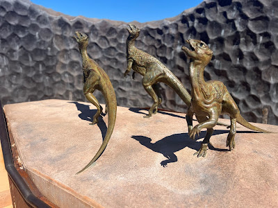
We spent an interesting morning at the Australian Age of Dinosaurs where we were guided through some of their laboratories and exhibits.  The Winton area is rich in dinosaur fossils and the Museum of Natural History within the park is a world-class home to Australia's largest collection of dinosaur fossils.  Of most interest was about a 100m of a muddy rock face that was lifted over a period of 3 years and placed under cover.  At this rock face a herd of at least 150 small two-legged dinosaurs, including carnivorous coelurosaurs about the size of chickens and slightly larger plant-eating ornithopods, came to drink at the edge of a lake.   Over 3,300 footprints of these long-extinct dinosaurs are scattered in the mud of the rock face as they fled the scene upon the arrival of a large theropod.  This snapshot of a few terrifying moments has been frozen in time, immortalising the event and making Winton home to the only known dinosaur stampede in the world.

We left Winton at 1pm for the short flight to Longreach.  We planned to meet one of my long-time flying buddy's Shelley Ross and her husband Pete in Longreach and, as luck would have it, we arrived in the circuit together at Longreach and Shelley landed right behind me in their Cessna 172.  I've been on several trips with Shelley and Pete in Australia and on our 2011 African flying trip.  They're great company and, on this occasion were accompanied By Kristen and Gabby in their Piper Archer.

We've got a day off in Longreach tomorrow so Bruce and Rob can visit the excellent Qantas Founders Museum and Australian Stockmans Hall of Fame.  I've been to both several times so apparently I'm going kayaking with Shelley and Pete!


Leg Summary
Winton (YWTN) - Longreach (YLRE)
Distance: 92nm (170km)
Time: 0.9hrs
Alt: 3,500ft


Checking if a Brontosaurus has bad breath


100's of dinosaur footprints made during a stampede


747-200 on display at Qantas Founders Museum, Longreach


Waltzing Matilda

Burke & Wills Roadhouse airstrip

Today I introduced Bruce and Rob to the vast nothingness that is the outback of northern Queensland.

Leaving Burketown we turned south for a short flight of 1.1 hous to to the Burke & Wills Roadhouse.  The Roadhouse is on the junction of the Burke Developmental Rd and Matilda Highway both of which are major routes across this isolated land.  Behind the roadhouse is a large dirt airstrip which we used today.  The airstrip is pretty basic and the windsock has long since been blown away.

The Burke & Wills Roadhouse is typical of the roadhouses you find in these parts.  It offers fuel, a caravan park, a restaurant, simple shop and basic mechanical repairs.  As we sat and had an early lunch, we watched many dusty "grey nomads" with their 4 x 4's and caravans stop for a well deserved break at this oasis in the middle of nowhere.

Our flight from the Burke & Wills Roadhouse to Winton was a bit hot and bumpy.  We started off at an altitude of 3500' but then climbed to 5500'.  Air cools at 3deg/1000' so is ~15 deg cooler than on the ground.  We were comfortable in the cooler air but the ride was only marginally better.

I love flying in the outback.  The magnificent emptiness of the place fascinates me.  Flying over land that's billiard table flat as far as the eye can see is so different from the country I fly over at home.  In parts of the Australian outback, like the Simpson and Stryzelecki Deserts, there's no trace of humanity.  However, on the leg to Winton we passed over stick tracks and remote stations miles from anywhere.  How they farm in such an inhospitable land is difficult to imagine.

Our route took us over the Combo Waterhole which I circled over for Bruce and Rob.  Combo Waterhole is  believed to be the setting for the story of Waltzing Matilda or to have inspired the famous Australian bush ballad.  Banjo Paterson, the composer of Waltzing Matilda, is known to have visited the site in 1895.  The song was first publicly played in October 1896 at Winton's North Gregory Hotel which still stands today.

Arriving at Winton we nearly became stranded.  Although Bruce, Rob and I all had cellphones using different carriers, none of us had coverage.  Winton airport is a long way out of town and we had no way of contacting the motel we were staying at to have them come and collect us as we'd arranged when booking. The airport looked abandoned on a Sunday afternoon but fortunately we found a guy pottering around with his helicopter who took pity on us and called the motel.  Note to self - when travelling in the outback buy a Telstra Sim card!

After a lazy afternoon hour or two at the motel and catching up on some washing, we wandered into town (which was surprisingly busy) for another pub meal and more chips.


Leg Summary
Burketown (YBKT) - Burke & Wills Roadhouse
Distance: 100nm (185km)
Time: 1.1hrs
Alt: 3,500ft

Burke & Wills Roadhouse - Winton (YKMB)
Distance: 244nm (452km)
Time: 2.3hrs
Alt: 3,500ft - 5,500ft  


Downwind at Burke & Wills Roadhouse airstrip


The magnificent emptiness of the Australian outback


The magnificent emptiness of the Australian outback
 
 
The magnificent emptiness of the Australian outback


Winton


Banjo Patterson
Composer of Waltzing Matilda


Main street Winton


Saturday, 12 August 2023

Cruisin' the coast


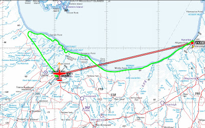
Our track around the coast of the Gulf of Carpentaria is shown.
Much more fun than a straight line!

Today we flew from Karumba to Burketown but, rather than fly the short 76nm (140km) straight line route between the two towns, we flew around the Gulf of Carpentaria coast.

After a nice breakfast, we and our bags were dropped back at the Karumba airport.  We're a well-oiled team now and within 25 mins the aircraft was packed, checked over thoroughly and we were rolling.  Climbing to 1000' we tracked down the coast and, when clear of civilisation, descended to 500' for our trip along the coast.

The coast of the Gulf of Carpentaria is fascinating in this area and it's one of my favourite places to fly.  It's inaccessible by road and even boats struggle in this part of the coast due to the shallow waters and mangrove swamps.  It's billiard table flat with large salt pans and, in the wet season (November to April), floods extensively.  There's no apparent coast - the land just seems to merge into the sea.

As we tracked westward the rivers and streams running into the Gulf become more numerous.  We followed a few in search of crocodiles but none were seen.  At the height we were flying we saw lots of tracks (of something) across the sand and salt pans but didn't sight anything but flocks of birds.  During the whole flight we never saw any sign of mankind.

The flying was lovely in calm and clear skies but it was time to actually go to our destination which we'd long since passed.  We climbed to 3000' and turned back toward Burketown.  From that height the rivers and tributaries look like a picture of veins and capillaries in a medical journal.

I've been to Burketown twice before; the last time in 2012.  It's a peaceful little isolated outback town that offers the only pub for miles around.  During my last visits I stayed in Donga's (cabins) behind the pub.  However, the old pub burnt down in 2012 shortly after I last visited.  It was an old rambling place and may have fallen down if hadn't burned down.  By October 2013 there was a brand new swanky pub in its place.  Such is the importance of a pub in an outback town.

We're staying at the Savannah Lodge which is lovely.  They even offered us the use of a car to have look around.  It doesn't take long.

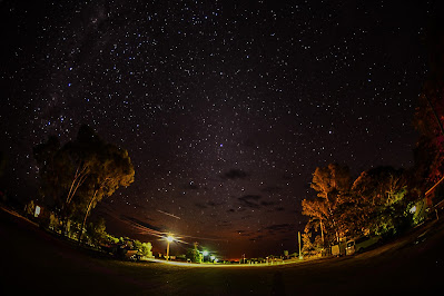
Bruce is a keen photographer and can be credited with most of the photos taken on this trip.  He's revelled this evening in putting his impressive camera gear into action for stunning pictures of the night sky which is spectacular out here.

Rivers and streams of the Gulf


Rivers and streams of the Gulf


Rivers and streams of the Gulf


Rivers and streams of the Gulf


Land blends into the sea in the Gulf of Carpentaria


Burketown artesion bore. Yes, the water is very hot


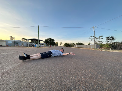
You can lie on the main road of Burketown without
much fear of being run over for an hour or two


Milky Way in Burketown night sky

Burketown night sky


Necessity breeds invention


Pilots don't trust fuel gauges and we always dip the fuel tanks to verify how much fuel we have on board and need for our next flight.  All light aircraft carry a dip stick calibrated for use with that aircraft

VH-DXJ's dip stick looked like a piece of petrified wood and it's markings were almost illegible.  It was dark in colour so when dipped into fuel it was difficult to tell the upper level of the fuel.  Right from the first day we flew I muttered and cursed VH-DXJ's dipstick.

Wandering around the supermarket at Airlie Beach Bruce spotted a wooden spoon and suggested we use that as a dipstick.  And it was on special!  We purchased that and Robert skillfully marked it with bread knife.  Hallelujah - we now had dipstick that was readable.  I ignore the stares from other pilots as I work around our aircraft when doing a pre-flight inspection carrying a wooden spoon.

Our new wooden spoon dipstick also offers a secondary benefit.  When Robert and Bruce start fighting in the plane, I can belt them with it just like our parents used to do :)


Original aircraft dipstick & our new and improved version


Friday, 11 August 2023

South down the west coast of the York Penisula

Thursday Island

Today we completed our coastal circumnavigation of the York Peninsula having flown north along the east coast of the peninsula to Cape York and south down the west coast to Karumba.

We’d landed on Horn Island off the coast of the York Peninsula and so were subject to strict bio-security requirements before flying back to mainland Australia.  There’s creepy crawlies in the islands of the Torres Strait they don’t want on the mainland so you have to provide prior notice of your arrival on Horn Island and present yourself to an Australian Biosecurity Officer before departure.  The Officer provides you with a pre-departure spray which must be used when the aircraft is packed and ready for departure and a top-of-descent spray which must be used on descent to your first point of landing on the mainland.  It’s not a difficult process to follow.

Bugs be gone
 

Horn Island airport is busy and, after being refuelled from a truck (a novelty for us Kiwi pilots), we had to taxi after an Alliance Fokker F28 jet, behind a stationary QantasLink Q300 and we led a Cessna Caravan onto the runway.

Taking off from Horn Island we did a wide circuit of Thursday Island where we’d stayed.  It was good to see the island from the air and its infrastructure.  All power on the island is supplied by diesel generators and the power station could be clearly seen on the north side of the island.  Nothing is grown on the island.  Everything is delivered by barge.

Leaving Thursday Island we set a southerly heading for our long multi-day trip back to Brisbane.  Our first stop was Weipa for fuel.  We only took what fuel we needed to reach Weipa at Horn Island as it was likely to be expensive.  It must be real expensive as the Horn Island refueller either didn’t know the price or was too scared to tell us.

North of Weipa are many bauxite mines all serviced by their own airstrips and small ports.  We saw tugs towing barges laden with minerals out to sea to who knows where.  New Zealand’s Bluff Aluminum smelter?  The refueller at Weipa told us the town was owned by Rio Tinto.

Before we began refuelling from the truck at Weipa, I dipped the aircraft’s fuel tanks and was concerned to feel the fuel bladder in the right-hand tank had lifted and felt squishy.  The 150 litres stored in each wing of a Cessna 182 is held in a bladder and I know they can be fragile.  I expected the worst and could think of better places to be stuck with a disabled aircraft than Weipa!  I called the engineer who looks after VH-DXJ and he told me not to worry.  He said that once the tank was full, the bladder would flatten out.  Phew!

It was a long leg from Weipa to Karumba.  There were periods of silence (I saw Robert nodding off beside me) but also many hilarious conversations about topics that should not be published.  We saw boats on very remote rivers and conjured up fanciful stories of drugs being landed from far off places and other nefarious activities.

We landed just on 5pm at Karumba.  With no cellphone coverage at this remote town, we had to leave our bags in the plane and walk 1 – 2km into town to find our accommodation and ask them to take us back to the airport to collect our bags.

Then it was into the bar.


Leg Summary
Horn Island (YHID) - Weipa (YBWP)
Planned Distance: 127nm (235km)
Time: 1.3hrs
Alt: 4,500ft

Weipa (YBWP) - Karumba (YKMB)
Distance: 292nm (541km)
Time: 2.6hrs
Alt: 4,500ft 

Bauxite mine


One of the many scenic tributaries and rivers


Fires lit by lightning or indigenous people are a common sight


Refuelling at Weipa


Coastal waters on west coast of York Peninsula


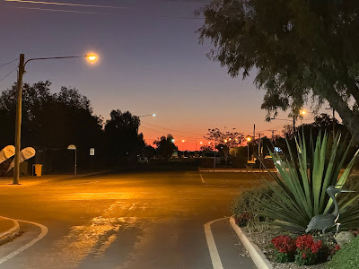
Gulf of Carpentaria approaching Karumba in the late afternoon